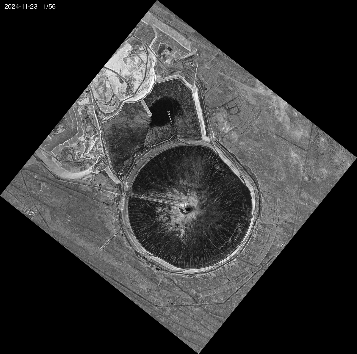
① Timelapse — 56 frames, 178 days
Inline GIF at 1200 px (47 MB).
Full 2200 px GIF (166 MB): download.
The 6 Jul/Aug 2024 frames were dropped — their NCC residuals were ~95 m, suggesting different SAR look direction. The 56 remaining frames (every 3 days, near-perfect alignment) make a clean dune-migration series.
② Deep-Zoom frame slider
③ Alignment verification
Open align_check.html to A/B compare any pair of frames with split or blink modes. Recommended checks: 2024-12-28 vs 2024-12-31, 2025-04-11 vs 2025-04-23.
④ How the change detection works
What you're looking at, in scientific terms.
The data
56 Sentinel-class sub-meter SAR amplitude scenes from Capella Space Open Data over the Telfer Mine (Western Australia, Great Sandy Desert) — every 3 days from 2024-11-23 to 2025-05-19. Each scene is a Geocoded Ellipsoid-Corrected (GEC) product at ~0.41 m/pixel native resolution. We chose Telfer because it pairs an active mining area with surrounding desert dunes, giving us both fast-moving and stable terrain in the same scene — useful for calibrating the change detector against a known-stable reference.
Coregistration (alignment between frames)
Frames are aligned to a reference (2025-02-05) via normalized cross-correlation (NCC) on a textured patch over the mine pit. Each frame gets a sub-pixel translation that brings ground features to the same image-pixel coordinates as the reference. Residual error is typically < 5 m (≈ 12 px). The 6 oldest frames (pre-2024-11-23) were dropped because their NCC residuals were ~95 m, indicating different look directions.
Change metric: shift-tolerant log-ratio
For each consecutive pair of frames, the image is divided into a regular grid of 64×64-px cells (≈ 26 m on the ground). For each cell:
- The patch from frame A is matched against a ±6 px window in frame B using NCC, locating the best sub-pixel alignment. This absorbs residual coregistration error.
- The amplitude log-ratio is computed at the best-aligned position:
|mean(log A) − mean(log B)|. Higher values = bigger brightness change that cannot be explained by alignment.
We use log-ratio rather than Pearson correlation because amplitude correlation collapses to ~0 on SAR speckle (the speckle pattern decorrelates between passes even on stable ground). Log-ratio is the standard amplitude-domain change detector in SAR literature.
Why not the InSAR coherence used by Alyounis et al. 2024 (Etihad Rail study)? True InSAR coherence needs the complex (phase) SAR product (SLC). Capella's open data is GEC (amplitude only). With Sentinel-1 SLC (free, 10 m) we would compute true InSAR coherence — that's the planned next step.
Per-pair baseline normalization
Each pair of frames has an overall "speckle decorrelation baseline" — even a perfectly stable scene shows ~0.05–0.20 log-ratio per cell due to per-pass radiometric drift, atmospheric variation, and residual speckle. We subtract the per-pair median from every cell, so what remains is the change relative to the stable baseline of that pair. This cancels global drift between acquisitions.
Spatial smoothing
Each cell's value is replaced with the mean of its 3×3 neighborhood at render time. Real changes are spatially contiguous (a lake, a mining pit, a moved dune); speckle outliers are isolated single cells. The smoothing kills salt-and-pepper noise while preserving the contour of real change patches.
What you see in the overlay
- Transparent: cell change is below threshold — surface is stable enough.
- Yellow → Orange → Red: cells with increasing anomalous change. Red ≈ log-ratio > 0.6 above baseline — major change (new water, fresh sand cover, mining activity).
- Particles (optional): drift only over cells that show change, colored by intensity. Direction is a coarse motion estimate from per-cell template matching (noisy on SAR speckle; treat as decoration, not data).
Known limitations
- Amplitude only, not phase. No interferometric coherence, no millimeter-scale deformation. Capella GEC product limitation.
- Sub-pixel coregistration noise. ±6 px shift tolerance absorbs most of it but isolated cells can still leak through, especially in highly textured areas.
- Speckle. ~26 m patches average ~4000 pixels of speckle each, but residual decorrelation is the dominant noise floor.
- Single-pair only. The Etihad Rail paper's full pipeline uses a stack inversion (PS+DS InSAR) to reduce per-pair noise by ~10×. Our per-pair view is closer to single-pair DInSAR.
Pipeline corridor relevance
For the pipeline-under-sand use case, the same change-detection pipeline applied to a Saudi corridor (e.g., the Shaybah pipeline alignment) at 3-day cadence would highlight segments where dune crests have moved, where surface moisture changed, or where new sand cover appeared — exactly the inputs needed for an Aramco-style corridor-risk index. This Telfer demo proves the chain works at sub-meter resolution; production would scale it across thousands of km of pipeline routes.